Comparing Sentinel-1, Sentinel-2, and Landsat-8 data in the early recognition of irrigated areas in central Italy

Submitted: 25 August 2021
Accepted: 31 October 2021
Published: 23 December 2021
Abstract Views: 1154
PDF: 501
HTML: 46
Publisher's note
All claims expressed in this article are solely those of the authors and do not necessarily represent those of their affiliated organizations, or those of the publisher, the editors and the reviewers. Any product that may be evaluated in this article or claim that may be made by its manufacturer is not guaranteed or endorsed by the publisher.

Authors

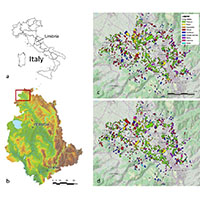
This study evaluated the effectiveness of various remote sensing (RS) data (Sentinel-1, Sentinel-2, and Landsat 8) in the early recognition of irrigated areas in a densely cultivated area of central Italy. The study was based on crop data collected on more than 2000 plots in 2016 and 2017, characterized by quite different climatic conditions. The different RS data sources were used both alone and combined and with precipitation to define corresponding random forest (RF) classifiers whose overall accuracy (OA) was assessed by gradually increasing the number of available features from the beginning of the irrigation season. All tested RF classifiers reach stable OAs (OA 0.9) after 7-8 weeks from the start of the irrigation season. The performance of the radar indexes slightly improves when used in combination with precipitation data, but three weeks of features are required to obtain OA above 80%. The optical indices alone (Sentinel-2 and Landsat 8) reach OA ≈85% in the first week of observation. However, they are ineffective in cloudy conditions or when rainfed and irrigated fields have similar vigour. The most effective and robust indices are those based on combined sources (radar, optical, and meteorological), allowing OAs of about 92% and 96% at the beginning and in the middle of the irrigation season, respectively.

Dimensions

Altmetric

PlumX Metrics

Downloads

Download data is not yet available.

Citations

Bazzi H., Baghdadi N., Ienco D., El Hajj M., Zribi M., Belhouchette H., Escorihuela M.J., Demarez V. 2019. Mapping irrigated areas using Sentinel-1 time series in Catalonia, Spain. Remote Sens. 11:1836. DOI: https://doi.org/10.3390/rs11151836
Bousbih S., Zribi M., El Hajj M., Baghdadi N., Lili-Chabaane Z., Gao Q., Fanise P. 2018. Soil moisture and irrigation mapping in a semi-arid region, based on the synergetic use of Sentinel-1 and Sentinel-2 Data. Remote Sens. 10:1953. DOI: https://doi.org/10.3390/rs10121953
Breiman L. 2001. Random forests. Mach. Learn. 45:5-32. DOI: https://doi.org/10.1023/A:1010933404324
Breiman L. 2002. Manual on setting up, using, and understanding random forests v3. 1. Tech. Report, Stat. Dep. Univ. Calif. Berkeley. Available from: http//oz.berkeley.edu/users/breiman
Cai X., Rosegrant M.W. 2002. Global water demand and supply projections: part 1. A modeling approach. Water Int. 27:159-69. DOI: https://doi.org/10.1080/02508060208686989
Calera A., Campos I., Osann A., D’Urso G., Menenti M. 2017. Remote sensing for crop water management: from ET modelling to services for the end users. Sensors. 17:1104. DOI: https://doi.org/10.3390/s17051104
Congalton R.G. 1991. A review of assessing the accuracy of classifications of remotely sensed data. Remote Sens. Environ. 37:35-46. DOI: https://doi.org/10.1016/0034-4257(91)90048-B
Cornes R.C., van der Schrier G., van den Besselaar E.J.M., Jones P.D. 2018. An ensemble version of the E-OBS temperature and precipitation data sets. J. Geophys. Res. Atmos. 123:9391-409. DOI: https://doi.org/10.1029/2017JD028200
Dari J., Quintana-Seguí P., Escorihuela M.J., Stefan V., Brocca L., Morbidelli R. 2021. Detecting and mapping irrigated areas in a Mediterranean environment by using remote sensing soil moisture and a land surface model. J. Hydrol. 596:126129. DOI: https://doi.org/10.1016/j.jhydrol.2021.126129
Dari J., Brocca L., Quintana-Seguí P., Escorihuela M.J., Stefan V., Morbidelli R., 2020. Exploiting high-resolution remote sensing soil moisture to estimate irrigation water amounts over a Mediterranean region. Remote Sens. 12:2593. DOI: https://doi.org/10.3390/rs12162593
Deines J.M., Kendall A.D., Hyndman D.W. 2019. Annual irrigation dynamics in the U.S. Northern high plains derived from landsat satellite data. Geophys. Res. Lett. 44:9350-60. DOI: https://doi.org/10.1002/2017GL074071
Deines J.M., Kendall A.D., Crowley M.A., Rapp J., Cardille J.A., Hyndman D.W. 2019. Mapping three decades of annual irrigation across the US High Plains Aquifer using Landsat and Google Earth Engine. Remote Sens. Environ. 233:111400. DOI: https://doi.org/10.1016/j.rse.2019.111400
Gao Q., Zribi M., Escorihuela M.J., Baghdadi N. 2017. Synergetic use of sentinel-1 and sentinel-2 data for soil moisture mapping at 100 m resolution. Sensors (Switzerland). 17:1966. DOI: https://doi.org/10.3390/s17091966
Gao Q., Zribi M., Escorihuela M., Baghdadi N., Segui P. 2018. Irrigation mapping using Sentinel-1 time series at field scale. Remote Sens. 10:1495. DOI: https://doi.org/10.3390/rs10091495
Huete A.R. 1988. A soil-adjusted vegetation index (SAVI). Remote Sens. Environ. 25:295-309. DOI: https://doi.org/10.1016/0034-4257(88)90106-X
Jalilvand E., Tajrishy M., Hashemi S.A.G., Brocca L. 2019. Quantification of irrigation water using remote sensing of soil moisture in a semi-arid region. Remote Sens. Environ. 231:111226. DOI: https://doi.org/10.1016/j.rse.2019.111226
Li X., Troy T.J. 2018. Changes in rainfed and irrigated crop yield response to climate in the western US. Environ. Res. Lett. 13:064031. DOI: https://doi.org/10.1088/1748-9326/aac4b1
Liaw A., Wiener M. 2002. Classification and regression by random forest. R News. 2-3:18-22.
Maselli F., Battista P., Chiesi M., Rapi B., Angeli L., Fibbi L., Magno R., Gozzini B. 2020a. Use of Sentinel-2 MSI data to monitor crop irrigation in Mediterranean areas. Int. J. Appl. Earth Obs. Geoinf. 93:102216. DOI: https://doi.org/10.1016/j.jag.2020.102216
Maselli F., Chiesi M., Angeli L., Fibbi L., Rapi B., Romani M., Sabatini F., Battista P. 2020b. An improved NDVI-based method to predict actual evapotranspiration of irrigated grasses and crops. Agric. Water Manag. 233:106077. DOI: https://doi.org/10.1016/j.agwat.2020.106077
Ozdogan M., Yang Y., Allez G., Cervante C. 2010. Remote sensing of irrigated agriculture: opportunities and challenges. Remote Sens. 2:2274-304. DOI: https://doi.org/10.3390/rs2092274
Pageot Y., Baup F., Inglada J., Baghdadi N., Demarez V. 2020. Detection of irrigated and rainfed crops in temperate areas using Sentinel-1 and Sentinel-2 time series. Remote Sens. 12:3044. DOI: https://doi.org/10.3390/rs12183044
Qi J., Kerr Y., Chehbouni A. 1994a. External factor consideration in vegetation index development. pp 723-730 in Proc. 6th Int. Symp. Phys. Meas. Signatures Remote Sens, France.
Qi J., Chehbouni A., Huete A.R., Kerr Y.H., Sorooshian S. 1994b. A modified soil adjusted vegetation index. Remote Sens. Environ. 48:119-26. DOI: https://doi.org/10.1016/0034-4257(94)90134-1
Richards J.A., Jia X. 2006. Remote sensing digital image analysis: An introduction. Springer, Berlin, Germany.
Rockström J., Falkenmark M., Lannerstad M., Karlberg L. 2012. The planetary water drama: dual task of feeding humanity and curbing climate change. Geophys. Res. Lett. 39. DOI: https://doi.org/10.1029/2012GL051688
Romero M., Luo Y., Su B., Fuentes S. 2018. Vineyard water status estimation using multispectral imagery from an UAV platform and machine learning algorithms for irrigation scheduling management. Comput. Electron. Agric. 147:109-17. DOI: https://doi.org/10.1016/j.compag.2018.02.013
Rosegrant M.W., Cline S.A. 2003. Global food security: challenges and policies. Science 302:1917-9. DOI: https://doi.org/10.1126/science.1092958
Rouse W., Haas R.H., Deering D.W. 1974. Monitoring vegetation systems in the Great Plains with ERTS, NASA SP-351. Third ERTS-1 Symp. Vol. 1.
Sepulcre-Cantó G., Zarco-Tejada P.J., Sobrino J.A., Berni J.A.J., Jiménez-Muñoz J.C., Gastellu-Etchegorry J.P. 2009. Discriminating irrigated and rainfed olive orchards with thermal ASTER imagery and DART 3D simulation. Agric. For. Meteorol. 149:962-75. DOI: https://doi.org/10.1016/j.agrformet.2008.12.001
Shiklomanov I.A. 2000. Appraisal and assessment of world water resources. Water Int. 25:11-32. DOI: https://doi.org/10.1080/02508060008686794
Vanino S., Pulighe G., Nino P., De Michele C., Falanga Bolognesi S., D’Urso G. 2015. Estimation of evapotranspiration and crop coefficients of tendone vineyards using multi-sensor remote sensing data in a Mediterranean environment. Remote Sens. 7:14708-730. DOI: https://doi.org/10.3390/rs71114708
Vanino S., Nino P., De Michele C., Falanga Bolognesi S., D’Urso G., Di Bene C., Pennelli B., Vuolo F., Farina R., Pulighe G. 2018. Capability of Sentinel-2 data for estimating maximum evapotranspiration and irrigation requirements for tomato crop in Central Italy. Remote Sens. Environ. 215:452-70. DOI: https://doi.org/10.1016/j.rse.2018.06.035
Veloso A., Mermoz S., Bouvet A., Le Toan T., Planells M., Dejoux J.F., Ceschia E. 2017. Understanding the temporal behavior of crops using Sentinel-1 and Sentinel-2-like data for agricultural applications. Remote Sens. Environ. 199:415-26. DOI: https://doi.org/10.1016/j.rse.2017.07.015
Vreugdenhil M., Wagner W., Bauer-Marschallinger B., Pfeil I., Teubner I., Rüdiger C., Strauss P. 2018. Sensitivity of Sentinel-1 backscatter to vegetation dynamics: an Austrian case study. Remote Sens. 10:1396. DOI: https://doi.org/10.3390/rs10091396
Xie Y., Lark T.J., Brown J.F., Gibbs H.K. 2019. Mapping irrigated cropland extent across the conterminous United States at 30 m resolution using a semi-automatic training approach on Google Earth Engine. ISPRS J. Photogramm. Remote Sensing 155:136-49. DOI: https://doi.org/10.1016/j.isprsjprs.2019.07.005
Weaver J., Moore B., Reith A., McKee J., Lunga D. 2018. A comparison of machine learning techniques to extract human settlements from high resolution imagery. in Proceedings of the International Geoscience and Remote Sensing Symposium (IGARSS). DOI: https://doi.org/10.1109/IGARSS.2018.8518528

How to Cite

Vergni, L., Vinci, A., Todisco, F., Santaga, F. S. and Vizzari, M. (2021) “Comparing Sentinel-1, Sentinel-2, and Landsat-8 data in the early recognition of irrigated areas in central Italy”, Journal of Agricultural Engineering, 52(4). doi: 10.4081/jae.2021.1265.