Technical Notes
Vol. 56 No. 4 (2025)
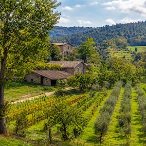
A test for monitoring erosion on the Cape Fear experimental hillslope using a low-cost camera
Publisher's note
All claims expressed in this article are solely those of the authors and do not necessarily represent those of their affiliated organizations, or those of the publisher, the editors and the reviewers. Any product that may be evaluated in this article or claim that may be made by its manufacturer is not guaranteed or endorsed by the publisher.
All claims expressed in this article are solely those of the authors and do not necessarily represent those of their affiliated organizations, or those of the publisher, the editors and the reviewers. Any product that may be evaluated in this article or claim that may be made by its manufacturer is not guaranteed or endorsed by the publisher.
Published: 28 July 2025
973
Views
309
Downloads
32
HTML
Authors
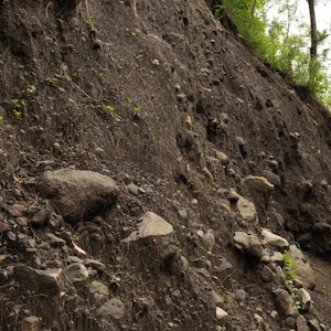
Remote sensing and image analysis are gaining popularity as low-cost, continuous alternatives to traditional soil erosion measurement methods. This technical note presents a comparison between direct erosion measurements and image-based estimates on a semi-natural hillslope, taken before and after an artificial rainfall event. Although discrepancies between the two methods ranged from 18% to 27%, the image-based approach successfully detects rills as small as 5-7 cm, highlighting its potential for real-time, continuous monitoring in field applications.
Downloads
Download data is not yet available.
Citations
Brady, N.C. 1990. The nature and properties of soils, 10th ed. New York, Macmillan Publishing Co.
Ehrhardt, A., Deumlich, D., Gerke, H.H. 2022. Soil surface micro-topography by structure-from-motion photogrammetry for monitoring density and erosion dynamics. Front. Environ. Sci. 9:737702. DOI: https://doi.org/10.3389/fenvs.2021.737702
Fernández Rodríguez, R., Ponte, M., Bento, R., Cardoso, R. 2022. Potential of mobile application based on structure from motion (SfM) photogrammetry to monitor slope fast erosion by runoff water. Catena 216:106359. DOI: https://doi.org/10.1016/j.catena.2022.106359
Manfreda, S., Miglino, D., Saddi, K.C., Jomaa, S., Eltner, A., Perks, M., et al. 2024. Advancing river monitoring using image-based techniques: challenges and opportunities. Hydrol. Sci. J. 69:657-677. DOI: https://doi.org/10.1080/02626667.2024.2333846
Maxwell ,C.M., Langarudi, S.P., Fernald, A.G. 2019. Simulating a watershed-scale strategy to mitigate drought, flooding, and sediment transport in drylands. Systems 7:53. DOI: https://doi.org/10.3390/systems7040053
Nicosia, A., Carollo, F.G., Di Stefano, C., Palmeri, V., Pampalone, V., Serio, M.A et al. 2024. The importance of measuring soil erosion by water at the field scale: a review. Water (Basel) 16:3427. DOI: https://doi.org/10.3390/w16233427
Noto, S., Tauro, F., Petroselli, A., Apollonio, C., Botter, G., Grimaldi, S. 2022. Low-cost stage-camera system for continuous water-level monitoring in ephemeral streams. Hydrol. Sci. J 67:1439-1448. DOI: https://doi.org/10.1080/02626667.2022.2079415
Palmeri V., Di Stefano C., Nicosia A., Pampalone V., Ferro V. 2024. Terrestrial photogrammetry–GIS methodology for measuring rill erosion at the Sparacia Experimental Area, Sicily. Remote Sens. 16:4232. DOI: https://doi.org/10.3390/rs16224232
Pampalone, V., Serio, M.A., Bagarello, V., Ferro ,V. 2024. Empirical modeling of soil erosion using unit plot data at Sparacia experimental area (southern Italy). J. Soils Sediments 24:2535-2547. DOI: https://doi.org/10.1007/s11368-024-03781-2
Petroselli A., Tauro F., 2017. Cape Fear: monitoring basic hydrological processes in an outdoor hillslope plot. Environmental Monitoring and Assessment 189, 132. DOI: https://doi.org/10.1007/s10661-017-5851-4
Sánchez-Crespo, F.A., Gómez-Villarino, M.T., Gallego, E., Fuentes, J.M., García, A.I., Ayuga, F. 2023. Monitoring of water and tillage soil erosion in agricultural basins, a comparison of measurements acquired by differential interferometric analysis of sentinel TopSAR images and a terrestrial LIDAR system. Land 12:408. DOI: https://doi.org/10.3390/land12020408
Tan, S.S.X., Kuebbing, S.E. 2023. A synthesis of the effect of regenerative agriculture on soil carbon sequestration in Southeast Asian croplands. Agr. Ecosyst. Environ. 349:108450. DOI: https://doi.org/10.1016/j.agee.2023.108450
Tauro, F., Noto, S., Botter, G., Grimaldi, S. 2022. Assessing the optimal stage-cam target for continuous water level monitoring in ephemeral streams: experimental evidence. Remote Sens. 14: 6064. DOI: https://doi.org/10.3390/rs14236064
Tauro, F., Petroselli, A., Fiori, A., Romano, N., Rulli, M.C., Porfiri, M., et al. 2017. “Cape Fear”– A hybrid hillslope plot for monitoring hydrological processes. Hydrology 4:35. DOI: https://doi.org/10.3390/hydrology4030035
Tauro, F., Petroselli, A., Grimaldi, S., 2023. Thinking inside the box: Investigating peak storm response in a simplified outdoor slope setup. J. Hydrol. 625:130064. DOI: https://doi.org/10.1016/j.jhydrol.2023.130064
Todisco, F., Vergni, L., Mannocchi, F., Bomba, C. 2012. Calibration of the soil loss measurement method at the Masse experimental station. Catena 91:4-9. DOI: https://doi.org/10.1016/j.catena.2011.02.003
Vinci, A., Todisco, F., Brigante, R., Mannocchi, F., Radicioni, F. 2017. A smartphone camera for the structure from motion reconstruction for measuring soil surface variations and soil loss due to erosion. Hydrol. Res. 48:673-685. DOI: https://doi.org/10.2166/nh.2017.075
Žížala, D., Zádorová, T., Kapička, J. 2017. Assessment of soil degradation by erosion based on analysis of soil properties using aerial hyperspectral images and ancillary data, Czech Republic. Remote Sens. 9:28. DOI: https://doi.org/10.3390/rs9010028
How to Cite
“A test for monitoring erosion on the Cape Fear experimental hillslope using a low-cost camera” (2025) Journal of Agricultural Engineering, 56(4). doi:10.4081/jae.2025.1786.
Copyright (c) 2025 the Author(s)


This work is licensed under a Creative Commons Attribution-NonCommercial 4.0 International License.