Monitoring and multi-scenario simulation of agricultural land changes using Landsat imageries and future land use simulation model on coastal of Alanya

Published: 31 October 2023
Abstract Views: 471
PDF: 61
Publisher's note
All claims expressed in this article are solely those of the authors and do not necessarily represent those of their affiliated organizations, or those of the publisher, the editors and the reviewers. Any product that may be evaluated in this article or claim that may be made by its manufacturer is not guaranteed or endorsed by the publisher.

Authors

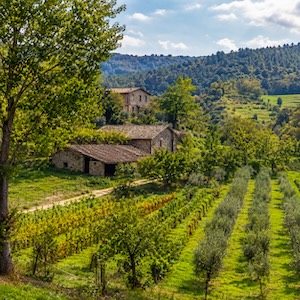
Anthropogenic activities have adverse impacts on productive lands around coastal zones due to rapid developments. Assessment of land use and land cover (LULC) changes provide a better understanding of the process for conservation of such vulnerable ecosystems. Alanya is one of the most popular tourism hotspots on the Mediterranean coast of Turkey, and even though the city faced severe LULC changes after the mid-80s due to tourism-related investments, limited number of studies has been conducted in the area The study aimed to determine short-term and long-term LULC changes and effects of residential development process on agricultural lands using six Landsat imageries acquired between 1984 and 2017, and presented the first attempt of future simulation in the area. Average annual conversions (AAC) (ha) were calculated to assess magnitudes of annual changes in six different periods. AACs were used to calculate area demands for LULC2030 and LULC2050, whereby annual conversions from different periods were multiplied by the number of years between 2017, 2030 and 2050 for each scenario. Finally, optimistic and pessimistic scenarios for agricultural lands are simulated using a future land use simulation model. Accordingly, agricultural lands decreased from 53.9% to 31.4% by 22.5% in 33 years and are predicted to change between 19.50% and 24.63% for 2030, 1.07% and 14.10% for 2050, based on pessimistic and optimistic scenarios, respectively.

Dimensions

Altmetric

PlumX Metrics

Downloads

Download data is not yet available.

Citations

Abbas Z., Yang G., Zhong Y., Zhao Y. 2021. Spatiotemporal change analysis and future scenario of LULC using the CAANN approach: A case study of the Greater Bay Area, China. Land. 10:584. DOI: https://doi.org/10.3390/land10060584
Akşit-Aşık N. 2016. Evaluation of the agricultural tourism potential of Gazipaşa: Swot analysis [In Turkish]. J. Int. Soc. Res. 9:1942-53. DOI: https://doi.org/10.17719/jisr.20164216302
Alam A., Bhat M.S., Maheen M. 2020. Using Landsat satellite data for assessing the land use and land cover change in Kashmir valley. GeoJournal 85:1529-43. DOI: https://doi.org/10.1007/s10708-019-10037-x
Amgoth A., Rani H.P., Jayakumar K.V. 2023. Exploring LULC changes in Pakhal Lake area, Telangana, India using QGIS MOLUSCE plugin. Spat. Inf. Res. 31. DOI: https://doi.org/10.1007/s41324-023-00509-1
Antalya Metropolitan Municipality Report (AMM). 2022. Available from: https://kbs.antalya.bel.tr
Awange J.L., Saleem A., Konneh S.S., Goncalves R.M., Kiema J.B.K. Hu K.X. 2018. Liberia’s coastal erosion vulnerability and LULC change analysis: Post-civil war and Ebola epidemic. Appl. Geogr. 101:56-67. DOI: https://doi.org/10.1016/j.apgeog.2018.10.007
Aydın A., Eker R. 2022. Future land use/land cover scenarios considering natural hazards using Dyna????CLUE in Uzungöl Nature Conservation Area (Trabzon????NE Türkiye). Nat. Hazards. 114:2683-707. DOI: https://doi.org/10.1007/s11069-022-05485-7
Baig M.F., Mustafa M.R.U., Baig I., Takaijudin H.B., Zeshan M.T. 2022. Assessment of land use land cover changes and future predictions using CA-ANN simulation for Selangor, Malaysia. Water. 14:402. DOI: https://doi.org/10.3390/w14030402
Bharatkar P.S., Patel R. 2013. Approach to accuracy assessment for RS image classification techniques. Int. J. Sci. Eng. Res. 4:79-86.
Burley T.M. 1961. Land use or land utilization? Prof. Geogr. 14:18-20. DOI: https://doi.org/10.1111/j.0033-0124.1961.136_18.x
Ceylan R.F., Ozkan B. 2020. Assessing impacts of COVID-19 on agricultural production and food systems in the world and in Turkey. Gaziantep Uni. J. Soc. Sci. SI:472-85. DOI: https://doi.org/10.21547/jss.784859
Copernicus, European Union, Copernicus Land Monitoring Service, European Environment Agency (EEA). 2018. Available from: https://land.copernicus.eu/paneuropean/corine-land-cover.
Çağlıyan A., Dağlı D. 2022. Monitoring land use land cover changes and modelling of urban growth using a future land use simulation model (FLUS) in Diyarbakır, Turkey. Sustainability 14:9180. DOI: https://doi.org/10.3390/su14159180
Çevik-Değerli B., Çetin M. 2022. Using the remote sensing method to simulate the land change in the year 2030. Turkish J. Agric. Food Sci. Technol. 10:2453-66. DOI: https://doi.org/10.24925/turjaf.v10i12.2453-2466.5555
Dey J., Sakhre S., Gupta V., Pathak S., Biniwale R., Viyaj R., Pathak S., Biniwale R., Kumar R. 2018. Geospatial assessment of tourism impact on land environment of Dehradun, Uttarakhand, India. Environ. Monit. Assess. 190:181. DOI: https://doi.org/10.1007/s10661-018-6535-4
Dogan Y., Dogan S., 2020. Coronavirus pandemic and its effect on crops production in Turkey. Artuklu Kaime Int. J. Econ. Admin. Res. 3:41-55.
Duhamel C. 2012. Land use and land cover, including their classification. Encylopedia Life Support Syst. 1:9.
EEA, 2011. European Environment Agency: Landscape fragmentation in Europe, Joint EEA-FOEN report no. 2/2011, EEA Report series, Publications Office of the European Union, Luxembourg.
Ellis E., 2007. Land-use and land-cover change. In Pontius R., Cleveland C.J.(eds.). Encyclopedia of Earth.
Fu P., Weng Q. 2018. Responses of Urban heat islands in Atlanta to different land-use scenarios. Theor. Appl. Climatol. 133:123-35. DOI: https://doi.org/10.1007/s00704-017-2160-3
Ghosh S., Das A., Hembram T.K., Saha S., Pradhan B., Alamri A.M. 2020. Impact of COVID-19 induced lockdown on environmental quality in four Indian megacities using Landsat 8 OLI and TIRS-derived data and Mamdani fuzzy logic modelling approach. Sustainability 12:5464. DOI: https://doi.org/10.3390/su12135464
Gökçe D., Pancar Z., Türk A. 2018. Determining the spatial vulnerability and adaptation capacity to climate change: A case study of Alanya [In Turkish]. J. Graduate School Nat. Appl. Sci. Mehmet Akif Ersoy Uni. 9:119-28. DOI: https://doi.org/10.29048/makufebed.403337
Grekousis G., Manetos P., Photis Y.N. 2013. Modeling urban evolution using neural networks, fuzzy logic and GIS: The case of the Athens metropolitan area. Cities 30:193-203. DOI: https://doi.org/10.1016/j.cities.2012.03.006
Guo M., Ma S., Wang L-J., Lin C. 2021. Impacts of future climate change and different management scenarios on water-related ecosystem services: A case study in the Jianghuai ecological economic Zone, China. Ecol. Indic. 127:107732. DOI: https://doi.org/10.1016/j.ecolind.2021.107732
Hamdy O., Zhao S., Osman T., Salheen M.A., Eid Y.Y. 2016. Applying a hybrid model of Markov chain and logistic regression to identify future urban sprawl in Abouelreesh, Aswan: A Case Study. Geosci. 6:43. DOI: https://doi.org/10.3390/geosciences6040043
Hind M., Muhammed S., Djamal A., Zoubida N. 2022. Assessment of land use–land cover changes using GIS, remote sensing, and CA–Markov model: A case study of Algiers, Algeria. Appl. Geomat.14:811-25. DOI: https://doi.org/10.1007/s12518-022-00472-w
Inalpulat M., Genç L. 2016. Land use land cover changes in response to urban sprawl within North-West Anatolia, Turkey. Int. J. Environ. Chem. Ecol. Geol. Geophys. Eng. 10:732-40.
Inalpulat M., Genç L. 2017. LULC changes against increasing residential area needs around Altinoluk, Turkey. Abstracts of International Congress on Landscape Architecture Research, Sarajevo, Bosnia Herzagovina, 1:20.
Inalpulat M., Genç L. 2021. Short-term change detection and markov chain prediction of greenhouse areas in Alanya, Turkey using Sentinel-2 imageries. Eur. J. Sci. Technol. 31:776-82. DOI: https://doi.org/10.31590/ejosat.1019033
İşler B, Aslan Z. 2021. Modeling the developments on urbanization and relationship with vegetation cover in Alanya. In International Archives of the Photogrammetry, Remote Sensing and Spatial Information Sciences, The 6th International Conference on Smart City Applications, Safranbolu, Turkey, 1:291-7. DOI: https://doi.org/10.5194/isprs-archives-XLVI-4-W5-2021-291-2021
Kafy A.-A., Dey N.N., Al Rakib A., Rahaman Z.A., Nasher N.M.R., Bhatt A. 2021. Modeling the relationship between land use/land cover and land surface temperature in Dhaka, Bangladesh using CA-ANN algorithm. Environ. Chal. 4:100190. DOI: https://doi.org/10.1016/j.envc.2021.100190
Lambin E.F., Rounsevell M.D.A., Geist H.J. 2000. Are agricultural land-use models able to predict changes in land-use intensity? Agr. Ecosyst. Environ. 82:321-31. DOI: https://doi.org/10.1016/S0167-8809(00)00235-8
Leta M.K., Demissie T.A., Tränckner J. 2021. Modeling and prediction of land use land cover change dynamics based on land change modeler (LCM) in Nashe Watershed, Upper Blue Nile Basin, Ethiopia. Sustainability 13:3740. DOI: https://doi.org/10.3390/su13073740
Leu T.C. 2019. Tourism as a livelihood diversification strategy among Sámi indigenous people in Northern Sweden. Acta Boreal. 36:75-92. DOI: https://doi.org/10.1080/08003831.2019.1603009
Liu X., Liang X., Li X., Xu X., Ou J., Chen Y., Li S., Wang S., Pei F. 2017. A future land use simulation model (FLUS) for simulating multiple land use scenarios by coupling human and natural effects. Landsc. Urban Plan. 168:94-116. DOI: https://doi.org/10.1016/j.landurbplan.2017.09.019
Lo C.P. 1986. Applied remote sensing. Longman Inc. New York, USA. p. 227
Lodato F., Colonna N., Pennazza G., Praticò S., Santonico M., Vollero L., Pollino M. 2023. Analysis of the spatiotemporal urban expansion of the Rome coastline through GEE and RF algorithm, using Landsat imagery. ISPRS Int. J. Geo-Inf. 12:141. DOI: https://doi.org/10.3390/ijgi12040141
Lu Y., Wu P., Ma X., Li X. 2019. Detection and prediction of land use/land cover change using spatiotemporal data fusion and the cellular automata-markov model. Environ. Monit. Assess.191:68. DOI: https://doi.org/10.1007/s10661-019-7200-2
Mahmoud H., Divigalpitiya P. 2019. Spatiotemporal variation analysis of urban land expansion in the establishment of new communities in upper Egypt: A case study of new Asyut city. Egypt. J. Remote Sens. Space Sci. 22:59-66. DOI: https://doi.org/10.1016/j.ejrs.2018.03.006
Mamitimin Y., Simayi Z., Mamat A., Maimaiti B., Ma Y. 2023. FLUS based modeling of the urban LULC in arid and semiarid region of Northwest China: A case study of Urumqi City. Sustainability 15:4912. DOI: https://doi.org/10.3390/su15064912
Martellozzo F., Amato F., Murgante B., Clarke K.C. 2018. Modelling the impact of urban growth on agriculture and natural land in Italy to 2030. Appl. Geogr. 91:156-67. DOI: https://doi.org/10.1016/j.apgeog.2017.12.004
Mehr A.D., Akdeğirmen O. 2021. Estimation of imperviousness and its impacts on flashfloods in Gazipaşa, Turkey. Knowl. Based Eng. Sci. 2:9-17. DOI: https://doi.org/10.51526/kbes.2021.2.1.9-17
MEUCC, Republic of Türkiye Ministry of Environment, Urbanization and Climate Change. 2018. Available from: https://tvk.csb.gov.tr
Modica G., Vizzari M., Pollino M., Fichera C.R., Zoccali P., Di Fazio S. 2012. Spatio-temporal analysis of the urban–rural gradient structure: An application in a Mediterranean mountainous landscape (Serra San Bruno, Italy). Earth Syst. Dynam. 3:263-79. DOI: https://doi.org/10.5194/esd-3-263-2012
Mohamed A., Worku H. 2020. Simulating urban land use and cover dynamics using cellular automata and Markov chain approach in Addis Ababa and the surrounding. Urban Clim. 31:100545. DOI: https://doi.org/10.1016/j.uclim.2019.100545
Nedd R., Light K., Owens M., James N., Johnson E., Anandhi A.A. 2021. Synthesis of land use/land cover studies: Definitions, classification systems, meta-studies, challenges and knowledge gaps on a global landscape. Land 10:994. DOI: https://doi.org/10.3390/land10090994
Noszczyk T.A. 2019. Review of approaches to land use changes modeling. Hum. Ecol. Risk Assess. Int. J. 25:1377-405. DOI: https://doi.org/10.1080/10807039.2018.1468994
Omar N.Q., Sanusi S.A.M., Hussin W.M.W., Samat N., Mohammed K.S. 2014. Markov-CA model using analytical hierarchy process and multiregression technique. IOP Conference Series: Earth and Environmental Science, 7th IGRSM International Remote Sensing & GIS Conference and Exhibition, Kuala Lumpur, Malaysia, 20:012008. DOI: https://doi.org/10.1088/1755-1315/20/1/012008
Özüpekçe S. 2020 Urbanization-tourism and environment relation in the east of Antalya, Turkey (Alanya-Manavgat). Int. Rev. Human. Sci. Res. 5:156-62.
Pandey B., Zhang Q., Seto K.C. 2018. Time series analysis of satellite data to characterize multiple land use transitions: a case study of urban growth and agricultural land loss in India. J. Land Use Sci. 13:221-37. DOI: https://doi.org/10.1080/1747423X.2018.1533042
Radwan T.M. 2019. Monitoring Agricultural expansion in a newly reclaimed area in the Western Nile Delta of Egypt using Landsat imageries. Agriculture. 9:137. DOI: https://doi.org/10.3390/agriculture9070137
Rwanga S.S., Ndambuki J.M. 2017. Accuracy assessment of land use/land cover classification using remote sensing and GIS. Int. J. Geosci. 8:611-22. DOI: https://doi.org/10.4236/ijg.2017.84033
Roy P.S., Roy A. 2010. Land use and land cover change in India: A remote sensing & GIS prespective. J. Indian Inst. Sci. 90:489-502.
Sakieh Y., Amiri B.J., Danekar A., Fegghi J., Dezhkam S. 2015. Scenario-based evaluation of urban development sustainability: An integrative modeling approach to compromise between urbanization suitability index and landscape pattern. Environ. Dev. Sustain. 17:1343-65. DOI: https://doi.org/10.1007/s10668-014-9609-7
Sengupta D., Chen R., Meadows M.E., Choi Y.R., Banerjee A., Zilong X. 2019. Mapping trajectories of coastal land reclamation in nine deltaic megacities using Google Earth Engine. Remote Sens. 11:2621. DOI: https://doi.org/10.3390/rs11222621
Seto K.C., Fragkias M., Guneralp B., Reilly M.K. 2011. A metaanalysis of global urban land expansion. PLoS ONE. 6:e23777. DOI: https://doi.org/10.1371/journal.pone.0023777
Shi Y., Qi Z., Liu X., Niu N., Zhang H. 2019. Urban land use and land cover classification using multisource remote sensing images and social media data. Remote Sens. 11:2719. DOI: https://doi.org/10.3390/rs11222719
Sönmez N.K., Selim S., Türkkan H.R., Onur I. 2016. Detections of the banana cultivated land use change in three years between 2004-2016 via rs and GIS: Case study of Gazipasa-Alanya/Turkey. Proc. 6th Remote Sensing and GIS Symposium, Adana-Turkey. 1:631-40.
Statuto D., Cillis G., Picuno P. 2019. GIS-based analysis of temporal evaluation of rural landscape: A case study in Southern Italy. Nat. Resour. Res. 28:61-75. DOI: https://doi.org/10.1007/s11053-018-9402-7
Uysal O., Veziroglu P. 2020. Overview of Turkish agriculture and future prospects in the COVID-19 pandemic. Turkish J. Agric. Food Sci. Technol. 8:2643-50. DOI: https://doi.org/10.24925/turjaf.v8i12.2643-2650.3849
Vijay R., Kushwaha V.K., Chaudhury A.S., Naik K., Gupta I., Kumar R., Wate S.R. 2016. Assessment of tourism impact on land use/land cover and natural slope in Manali, India: A geospatial analysis. Environ. Earth Sci. 72:20. DOI: https://doi.org/10.1007/s12665-015-4858-9
Xiang H., Ma Y., Zhang R., Chen H., Yang Q. 2022. Spatio-temporal evolution and future simulation of agricultural land use in Xiangxi, Central China. Land. 11:587. DOI: https://doi.org/10.3390/land11040587
Xie Z., Chen Y., Lu D., Li G., Chen E. 2019. Classification of land cover, forest, and tree species classes with ZiYuan-3 multispectral and stereo data. Remote Sens. 11:164. DOI: https://doi.org/10.3390/rs11020164
Yaghobi S., Faramarzi M., Karimi H., Sarvarian, J. 2019. Simulation of land-use changes in relation to changes of groundwater level in arid rangeland in western Iran. Int. J. Environ. Sci. Te. 16:1637-48. DOI: https://doi.org/10.1007/s13762-017-1610-x
Yang C., Wei T., Li Y. 2022. Simulation and spatio-temporal variation characteristics of LULC in the context of urbanization construction and ecological restoration in the Yellow River Basin. Sustainability 14:789. DOI: https://doi.org/10.3390/su14020789
Yatoo S.A., Sahu P., Kalubarme M.H., Kansara B.B. 2020. Monitoring land use changes and its future prospects using cellular automata simulation and artificial neural network for Ahmedabad city, India. Geo J. 85:1-22. DOI: https://doi.org/10.1007/s10708-020-10274-5
Yenigül S.B. 2016. The role of urban agriculture and local authorities in protecting agricultural land in Metropolitan Cities [In Turkish]. Megaron. 11:91-299. DOI: https://doi.org/10.5505/megaron.2016.48568
Zhang C., Wang P., Xiong P., Li C., Quan B. 2021. Spatial pattern simulation of land use based on FLUS model under ecological protection: A case study of Hengyang City. Sustainability 13:10458. DOI: https://doi.org/10.3390/su131810458
Zhu K., Cheng Y., Zang W., Zhou Q., El Archi Y., Mousazadeh H., Kabil M., Csobán K., Dávid L.D. 2023. Multiscenario simulation of land-use change in Hubei Province, China based on the Markov-FLUS Model. Land. 12:744. DOI: https://doi.org/10.3390/land12040744
Zope P.E., Eldho T.I., Jothiprakash V. 2015. Impacts of urbanization on flooding of coastal urban catchment: A case study of Mumbai City, India. Nat. Hazards. 75:887-908. DOI: https://doi.org/10.1007/s11069-014-1356-4

How to Cite

Inalpulat, M. (2023) “Monitoring and multi-scenario simulation of agricultural land changes using Landsat imageries and future land use simulation model on coastal of Alanya”, Journal of Agricultural Engineering, 55(1). doi: 10.4081/jae.2024.1548.