Best practices in post-flood surveys: The study case of Pioverna torrent

Submitted: 23 November 2021
Accepted: 23 February 2022
Published: 28 June 2022
Abstract Views: 2264
PDF: 325
HTML: 19
Publisher's note
All claims expressed in this article are solely those of the authors and do not necessarily represent those of their affiliated organizations, or those of the publisher, the editors and the reviewers. Any product that may be evaluated in this article or claim that may be made by its manufacturer is not guaranteed or endorsed by the publisher.

Authors

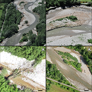
Floods cause fatalities and considerable economic damage to infrastructures and settlements, besides impacting fluvial-geomorphic landforms. The increase in the frequency and magnitude of flood events has contributed to inevitably gaining public concern over the flood risk and awareness of the necessity to improve forecasting and monitoring streamflows. In this context, an efficient and systematic procedure of post-event surveys that documents the impacts of a flood event over the territory is often missing. Flood areas delimitation, erosion-sediment variation, and riparian vegetation change are often neglected. The present study shows the field- and desk-based post-flood surveys conducted after an extreme event occurred on June 12th, 2019, along the Pioverna torrent in Valsassina (North Italy). The post-flood surveys consist in collecting meteorological data and time-series satellite images to detect the land cover change (identifying areas covered by water, sediments, and vegetation), and in planning, a few weeks later, an unmanned aerial vehicle (UAV)-based survey to observe the riverbed and streambank change and the modifications in vegetation patterns through high-resolution derived-topographic data. The results show accurate maps of a ground classification from satellite-based elaboration and high-resolution digital elevation models from UAV-based surveys that can support restoration activities and the design of effective countermeasures. This practical application is appropriate and suitable as a river management strategy regarding timing, resources, and economic costs. Thus, standardising the procedure could be essential for creating a historical database, useful to improve specific guidelines and postemergency management strategies.

Dimensions

Altmetric

PlumX Metrics

Downloads

Download data is not yet available.

Citations

Borga M., Anagnostou E.N., Blöschl G., Creutin J.D. 2011. Flash flood forecasting, warning and risk management: the HYDRATE project. Environ. Sci. Policy 14:834-44. DOI: https://doi.org/10.1016/j.envsci.2011.05.017
Borga M., Gaume E., Creutin J.D., Marchi L. 2008. Surveying flash floods: gauging the ungauged extremes. Hydrol. Process. 22:3883-5. DOI: https://doi.org/10.1002/hyp.7111
Brasington J., Langham J., Rumsby B. 2003. Methodological sensitivity of morphometric estimates of coarse fluvial sediment transport. Geomorphology 53:299-316. DOI: https://doi.org/10.1016/S0169-555X(02)00320-3
Brasington J., Rumsby B.T., Mcvey R.A. 2000. Monitoring and modelling morphological change in a braided gravel-bed river using high resolution GPS-based survey. Earth Surf. Process. Landforms 25:973-90. DOI: https://doi.org/10.1002/1096-9837(200008)25:9<973::AID-ESP111>3.0.CO;2-Y
Breiman L. 2001. Random forests. Machine Learn. 45:5-32. DOI: https://doi.org/10.1023/A:1010933404324
Breiman L., Friedman J., Stone C.J., Olshen R.A. 1984. Classification and regression trees. Taylor & Francis, London, UK.
Carbonneau, P.E., Lane, S.N., Bergeron, N.E., 2004. Catchment-scale mapping of surface grain size in gravel bed rivers using airborne digital imagery. Water Resour. Res. 40:W07202. DOI: https://doi.org/10.1029/2003WR002759
Carbonneau P.E., Piégay H. (Eds.). 2012. Fluvial remote sensing for science and management, in: Fluvial Remote Sensing for Science and Management. John Wiley & Sons, Ltd, Chichester, UK, pp. i-xx. DOI: https://doi.org/10.1002/9781119940791
Chappell A., Heritage G.L., Fuller I.C., Large A.R.G., Milan D.J. 2003. Geostatistical analysis of ground-survey elevation data to elucidate spatial and temporal river channel change. Earth Surf. Process. Landforms 28:349-70. DOI: https://doi.org/10.1002/esp.444
Chignell S., Anderson R., Evangelista P., Laituri M., Merritt D. 2015. Multi-temporal independent component analysis and Landsat 8 for delineating maximum extent of the 2013 Colorado Front Range flood. Remote Sensing 7:9822-43. DOI: https://doi.org/10.3390/rs70809822
Cislaghi A., Chiaradia E.A., Bischetti G.B. 2016. A comparison between different methods for determining grain distribution in coarse channel beds. Int. J. Sediment Res. 31:97-109. DOI: https://doi.org/10.1016/j.ijsrc.2015.12.002
Cohen J. 1960. A coefficient of agreement for nominal scales. Educ. Psychol. Measure. 20:37-46. DOI: https://doi.org/10.1177/001316446002000104
Cucchiaro S., Cavalli M., Vericat D., Crema S., Llena M., Beinat A., Marchi L., Cazorzi F. 2018. Monitoring topographic changes through 4D-structure-from-motion photogrammetry: application to a debris-flow channel. Environ Earth Sci 77:632. DOI: https://doi.org/10.1007/s12665-018-7817-4
Detert M., Kadinski L., Weitbrecht V. 2018. On the way to airborne gravelometry based on 3D spatial data derived from images. Int. J. Sediment Res. 33:84-92. DOI: https://doi.org/10.1016/j.ijsrc.2018.02.001
Entwistle N., Heritage G., Milan D. 2018. Recent remote sensing applications for hydro and morphodynamic monitoring and modelling: remote sensing for hydro and morphodynamic monitoring & modelling. Earth Surf. Process. Landforms 43:2283-91. DOI: https://doi.org/10.1002/esp.4378
Fogliata P., Cislaghi A., Sala P., Giupponi L. 2021. An ecological analysis of the riparian vegetation for improving the riverine ecosystem management: the case of Lombardy region (North Italy). Landscape Ecol. Eng. 17:375-86. DOI: https://doi.org/10.1007/s11355-021-00451-0
Folador L., Cislaghi A., Vacchiano G., Masseroni D. 2021. Integrating remote and in-situ data to assess the hydrological response of a post-fire watershed. Hydrology 8:169. DOI: https://doi.org/10.3390/hydrology8040169
Fonstad M.A., Marcus W.A. 2010. High resolution, basin extent observations and implications for understanding river form and process. Earth Surf. Process. Landforms 35:680-98. DOI: https://doi.org/10.1002/esp.1969
Fuller I.C., Large A.R.G., Milan D.J. 2003. Quantifying channel development and sediment transfer following chute cutoff in a wandering gravel-bed river. Geomorphology 54:307-23. DOI: https://doi.org/10.1016/S0169-555X(02)00374-4
Gaume, E., Borga, M., 2008. Post-flood field investigations in upland catchments after major flash floods: proposal of a methodology and illustrations: post-flood field investigations in upland catchments. J. Flood Risk Manage. 1:175-89. DOI: https://doi.org/10.1111/j.1753-318X.2008.00023.x
Grabowski R.C., Surian N., Gurnell A.M. 2014. Characterizing geomorphological change to support sustainable river restoration and management. WIREs Water 1:483-512. DOI: https://doi.org/10.1002/wat2.1037
Gurnell A.M., Rinaldi M., Belletti B., Bizzi S., Blamauer B., Braca G., Buijse A.D., Bussettini M., Camenen B., Comiti F., Demarchi L., García de Jalón D., González del Tánago M., Grabowski R.C., Gunn I.D.M., Habersack H., Hendriks D., Henshaw A.J., Klösch M., Lastoria B., Latapie A., Marcinkowski P., Martínez-Fernández V., Mosselman E., Mountford J.O., Nardi L., Okruszko T., O’Hare M.T., Palma M., Percopo C., Surian N., van de Bund W., Weissteiner C., Ziliani L. 2016. A multi-scale hierarchical framework for developing understanding of river behaviour to support river management. Aquat. Sci. 78:1-16. DOI: https://doi.org/10.1007/s00027-015-0424-5
Hashemi-Beni L., Jones J., Thompson G., Johnson C., Gebrehiwot A. 2018. Challenges and opportunities for UAV-based digital elevation model generation for flood-risk management: a case of Princeville, North Carolina. Sensors 18:3843. DOI: https://doi.org/10.3390/s18113843
Heritage G.L., Milan D.J., Large A.R.G., Fuller I.C. 2009. Influence of survey strategy and interpolation model on DEM quality. Geomorphology 112:334-44. DOI: https://doi.org/10.1016/j.geomorph.2009.06.024
Hooke J.M. 2008. Temporal variations in fluvial processes on an active meandering river over a 20-year period. Geomorphology 100:3-13. DOI: https://doi.org/10.1016/j.geomorph.2007.04.034
Javernick L., Brasington J., Caruso B. 2014. Modeling the topography of shallow braided rivers using Structure-from-Motion photogrammetry. Geomorphology 213:166-82. DOI: https://doi.org/10.1016/j.geomorph.2014.01.006
Lakshmi V. (Ed.). 2017. Remote sensing of hydrological extremes, Springer Remote Sensing/Photogrammetry. Springer International Publishing, Cham., Berlin, Germany. DOI: https://doi.org/10.1007/978-3-319-43744-6
Lane S.N. 2000. The measurement of river channel morphology using digital photogrammetry. Photogram. Record 16:937-61. DOI: https://doi.org/10.1111/0031-868X.00159
Lane S.N. Richards K.S. Chandler J.H. 1994. Developments in monitoring and modelling small-scale river bed topography. Earth Surf. Process. Landforms 19:349-68. DOI: https://doi.org/10.1002/esp.3290190406
Lane S.N., Westaway R.M., Murray Hicks D. 2003. Estimation of erosion and deposition volumes in a large, gravel-bed, braided river using synoptic remote sensing. Earth Surf. Process. Landforms 28:249-71. DOI: https://doi.org/10.1002/esp.483
Legleiter C.J., Roberts D.A., Lawrence R.L. 2009. Spectrally based remote sensing of river bathymetry. Earth Surf. Process. Landforms 34:1039-59. DOI: https://doi.org/10.1002/esp.1787
Marchi L., Borga M., Preciso E., Gaume E. 2010. Characterisation of selected extreme flash floods in Europe and implications for flood risk management. J. Hydrol. 394:118-33. DOI: https://doi.org/10.1016/j.jhydrol.2010.07.017
Micheletti N., Chandler J.H., Lane S.N. 2015. Investigating the geomorphological potential of freely available and accessible structure-from-motion photogrammetry using a smartphone. Earth Surf. Process. Landforms 40:473-86. DOI: https://doi.org/10.1002/esp.3648
Milan D.J., Heritage G.L., Large A.R.G., Fuller I.C. 2011. Filtering spatial error from DEMs: Implications for morphological change estimation. Geomorphology 125:160-71. DOI: https://doi.org/10.1016/j.geomorph.2010.09.012
Molinari D., Menoni S., Ballio F. (Eds.) 2017. Flood damage survey and assessment: new insights from research and practice. Geophysical Monograph Series. John Wiley & Sons, Inc., Hoboken, NJ, USA. DOI: https://doi.org/10.1002/9781119217930
Norbiato D., Borga M., Sangati M., Zanon F. 2007. Regional frequency analysis of extreme precipitation in the eastern Italian Alps and the August 29, 2003 flash flood. J. Hydrol. 345:149-66. DOI: https://doi.org/10.1016/j.jhydrol.2007.07.009
Notti D., Giordan D., Caló F., Pepe A., Zucca F., Galve J. 2018. Potential and limitations of open satellite data for flood mapping. Remote Sens. 10:1673. DOI: https://doi.org/10.3390/rs10111673
Paprotny D., Sebastian A., Morales-Nápoles O., Jonkman S.N. 2018. Trends in flood losses in Europe over the past 150 years. Nat Commun 9:1985. DOI: https://doi.org/10.1038/s41467-018-04253-1
Perignon M.C., Tucker G.E., Griffin E.R., Friedman J.M., 2013. Effects of riparian vegetation on topographic change during a large flood event, Rio Puerco, New Mexico, USA: Vegetation effects on topographic change. J. Geophys. Res. Earth Surf. 118:1193-209. DOI: https://doi.org/10.1002/jgrf.20073
Picco L., Comiti F., Mao L., Tonon A., Lenzi M.A. 2017. Medium and short term riparian vegetation, island and channel evolution in response to human pressure in a regulated gravel bed river (Piave River, Italy). Catena 149:760-9. DOI: https://doi.org/10.1016/j.catena.2016.04.005
Rahman Md.S., Di L. 2017. The state of the art of spaceborne remote sensing in flood management. Nat Hazards 85:1223-48. DOI: https://doi.org/10.1007/s11069-016-2601-9
Scorpio V., Surian N., Cucato M., Dai Prá E., Zolezzi G., Comiti F. 2018. Channel changes of the Adige River (Eastern Italian Alps) over the last 1000 years and identification of the historical fluvial corridor. J. Maps 14:680-91. DOI: https://doi.org/10.1080/17445647.2018.1531074
Seier G., Stangl J., Schöttl S., Sulzer W., Sass O. 2017. UAV and TLS for monitoring a creek in an alpine environment, Styria, Austria. Int. J. Remote Sens. 38:2903-20. DOI: https://doi.org/10.1080/01431161.2016.1277045
Simons J.H.E.J., Bakker C., Schropp M.H.I., Jans L.H., Kok F.R., Grift R.E. 2001. Man-made secondary channels along the River Rhine (The Netherlands); results of post-project monitoring. Regul. Rivers: Res. Mgmt. 17:473-91. DOI: https://doi.org/10.1002/rrr.661
Tamminga A.D., Eaton B.C., Hugenholtz C.H., 2015a. UAS-based remote sensing of fluvial change following an extreme flood event. Earth Surf. Process. Landforms 40:1464-76. DOI: https://doi.org/10.1002/esp.3728
Tamminga A.D., Hugenholtz C.H., Eaton B.C., Lapointe M. 2015b. Hyperspatial remote sensing of channel reach morphology and hydraulic fish habitat using an Unmanned Aerial Vehicle (UAV): a first assessment in the context of river research and management. River Res. Applic. 31:379-91. DOI: https://doi.org/10.1002/rra.2743
Tarolli P., Pijl A., Cucchiaro S., Wei W. 2020. Slope instabilities in steep cultivation systems: Process classification and opportunities from remote sensing. Land Degrad Dev Ldr. 3798. DOI: https://doi.org/10.1002/ldr.3798
Taylor N.J., Simeone C.E. 2021. Practical field survey operations for flood insurance rate maps, U.S. Geol. Survey Open-File Report 2020-1146. DOI: https://doi.org/10.3133/ofr20201146
Tomsett C., Leyland J. 2019. Remote sensing of river corridors: a review of current trends and future directions. River Res. Applic. 35:779-803. DOI: https://doi.org/10.1002/rra.3479
Torres-Sánchez J., Peña J.M., de Castro A.I., López-Granados F. 2014. Multi-temporal mapping of the vegetation fraction in early-season wheat fields using images from UAV. Comput. Electron. Agric. 103:104-13. DOI: https://doi.org/10.1016/j.compag.2014.02.009
Wang Y., Colby J.D., Mulcahy K.A. 2002. An efficient method for mapping flood extent in a coastal floodplain using Landsat TM and DEM data. Int. J. Remote Sens. 23:3681-96. DOI: https://doi.org/10.1080/01431160110114484
Wechsler S.P., Kroll C.N. 2006. Quantifying DEM uncertainty and its effect on topographic parameters. Photogramm. Eng. Remote Sensing 72:1081-90. DOI: https://doi.org/10.14358/PERS.72.9.1081
Williams R.D. 2012. DEMs of difference. Geomorphological techniques. Br. Soc. Geomorphol. 2:1-17.
Wise S.M. 2007. Effect of differing DEM creation methods on the results from a hydrological model. Comput. Geosci. 33:1351-65. DOI: https://doi.org/10.1016/j.cageo.2007.05.003

How to Cite

Cislaghi, A. and Bischetti, G. B. (2022) “Best practices in post-flood surveys: The study case of Pioverna torrent”, Journal of Agricultural Engineering, 53(2). doi: 10.4081/jae.2022.1312.